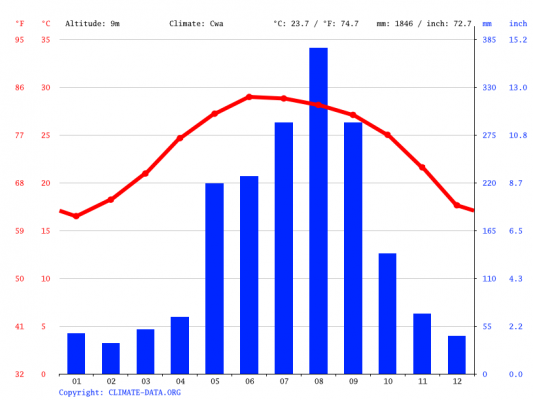
Climat moyen annuel à Thanh Hoa
Here below, an overview of the climatic averages over the whole year in Thanh Hóa:
- Minimum annual temperature: 21°C
- Average annual temperature: 24°C
- Maximum annual temperature: 27°C
- Precipitation: 133 mm/month (with 10 rainy days/month)
Monthly climate normals
| Min / Max | Precipitation | |
| January | 15 ° / 20 ° | 19mm / 8 days |
| february | 17 ° / 21 ° | 13mm / 9 days |
| March | 18 ° / 23 ° | 39mm / 12 days |
| April | 22 ° / 27 ° | 43mm / 9 days |
| may | 24 ° / 31 ° | 171mm / 12 days |
| June | 26 ° / 34 ° | 158mm / 10 days |
| July | 26 ° / 33 ° | 177mm / 11 days |
| August | 26 ° / 32 ° | 293mm / 15 days |
| September | 24 ° / 31 ° | 378mm / 14 days |
| October | 23 ° / 29 ° | 213mm / 12 days |
| November | 19 ° / 26 ° | 58mm / 5 days |
| December | 16 ° / 22 ° | 32mm / 6 days |
Weather stats were calculated using information from the THANH HOA weather station. The latter is located in Vietnam, 6 km from Thanh Hóa and is located at an altitude of 5 meters.
The best time to go, or the months to avoid
Below are some additional details that should allow you to choose the best times to leave, or the worst times.
Which are the warmest months in Thanh Hóa?
In Thanh Hóa, the months of the year with the highest maximum temperatures are:
June (with 34°C), July (with 33°C), August (with 32°C), …
What are the coldest months?
The months of the year with the lowest average temperatures in Thanh Hóa are:
January (with 18°C), December (with 19°C), february (with 19°C), …
Which are the driest months in Thanh Hóa?
In Thanh Hóa, the months of the year with the fewest rainy days are:
November (with 5 rainy days/month), December (with 6 rainy days/month), January (with 8 rainy days/month), …
What are the rainiest months?
The months with the most rainy days in Thanh Hóa are:
August (with 15 rainy days/month), September (with 14 rainy days/month), March (with 12 rainy days/month), …
What is the weather around?
Around Thanh Hoa
You might also be interested in these cities:
Vinh (à 126 km de Thanh Hoa), Hanoï (à 136 km), Hai Phong (à 152 km), …
In Vietnam
Check the climate forecasts for other major cities in Vietnam:
Ho Chi Minh Ville (à 1002 km de Thanh Hoa), Hanoï (à 136 km), Da Nang (à 489 km), Hai Phong (à 152 km), Nha Trang (à 916 km), Quy Nhon (à 764 km). ), Vinh (à 126 km), Phan Thiet (à 1018 km), Ca Mau (à 1183 km), Lang Son (à 251 km), …
The traveler's toolbox 🧳
Prepare, compare, and book your trip with our selection of must-see sites:
🛏 Booking: find your hotel/accommodation around the world
🔁 HomeExchange: the #1 home exchange platform
✈️ Skyscanner: surely the best flight comparator
⏱ LastMinute: the best offers for leaving at the last minute
🚗 RentalCars: search and compare car rental
🎟 GetYourGuide: book unforgettable tours and experiences